
19th Century Mapping Confusion and Dokdo
During the mid-1800s, inaccurate European maps began to affect Japanese maps of the region. There is great speculation as to how this altered the Meiji government´s decisions regarding possession and cartographical representations of Ulleungdo and Dokdo. To clarify what was going on at the time, no single map or document can uncover exactly how confused the Japanese were. However, gathering related maps and documents before, during, and after this time, we can paint a better picture of the Meiji government´s understanding of Ulleungdo-Dokdo. But first, we must review Japanese maps that predate these errors to determine whether or not the Japanese had established a reasonably clear perception of the area before the mapping confusion of this era.
This 1783 Japanese map shows Ulleungdo labeled as (þÆÆ—) and Dokdo as (ÃÌÆ—). This positioning of the islands is typical from this period up until around the middle of the 19th century.
The 19th Century Mapping Confusion Regarding Dokdo
In 1787 French navigator, Calaup de la Perouse found Ulleungdo and named it ´Dagelet´: In 1789 British explorer James Colnett also found Ulleungdo and named it ´Argonaut´. The latitude and longitude of Ulleungdo surveyed by la Perouse and Colnett were different and two separate islands appeared in European maps. Thus, these maps showed two Ulleungdo Islands. Later Phillip Franz von Siebold who stayed in Japan for seven years went back to the Netherlands and published maps of Japan applying the name of Takeshima to Argonaut and Matsushima to Dagelet.
Phillip Franz von Siebold´s 1840 map (above) shows the fictitious ´Argonaut Island´ as Takeshima and ´Dagelet Island´ as Matsushima. Both islands are simply Ulluengdo Island mapped twice in two different locations by two different explorers.

This 1847 Map by Marzolla Bendetto shows typical positioning and naming of maps affected by Seibolds error.
Japanese maps would later borrow these incorrect longitudes and latitudes and apply them to their own maps by labeling them as Ulleungdo (þÆÆ—) and Dokdo (ÃÌÆ—) as we see below. At this point, the only error of these maps is poor positioning.
This 19th century Japanese map shows Ulleungdo-Takeshima (þÆÆ—) mapped in the position of Argonaut Island and Dokdo (ÃÌÆ—) in the position of Dagelet.. The Japanese Kanji writing (ä¡ëåí·ŠÂõÈþÑÄÅŠÔþÑ) confirms the identity of the western island as Ulleungdo.
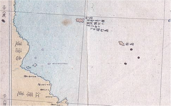
This 1876 map by Kashihara Yoshinaga is important. It clearly illustrates that the Japanese perceived Ulleungdo and Dokdo in more westerly locations. The island in the Argonaut position on the left has text stating "Japanese name Takeshima and Korean name Ulleungdo". Further South, observe that Songdo is mapped and double-labeled as Matsushima (Dokdo)
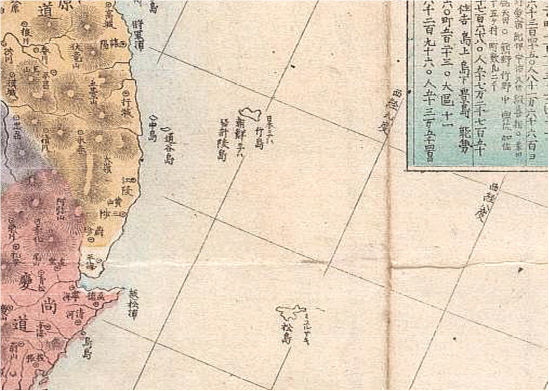
In 1877 the same Japanese cartographer as above (Kashihara Yoshinaga) repositioned and renamed the islands. Ulleungdo became Songdo and the former Songdo now became Liancourt Rocks.. Jukdo Island that was once the phantom À¯ArgonautÀÝ was deleted.
The ´Three Island Confusion´ Era
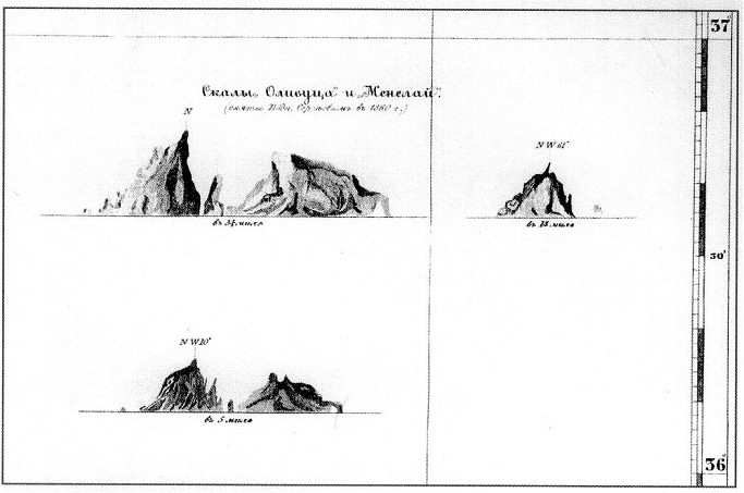
In 1849, the French whaler Liancourt reported the "discovery" of an island (Dokdo) in the East Sea (Sea of Japan), and Dokdo began to appear in European maps as ´Liancourt Rocks´. Later, in 1854, the Russian warship Pallada surveyed Dokdo and named it ´Manala and Olivutsa Rocks´ but Liancourt Rocks continued to appear in European maps. Thus three islands Argonaut, Dagelet and Liancourt Rocks began to appear in European and some Japanese maps. In 1855, the British ship Hornet also found Dokdo and named it ´Hornet Rocks´.

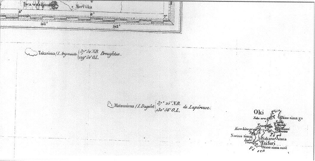
James Wyld´s map dated 1859 shows three islands with Argonaut included.

This 1872 map shows the three island error created upon the discovery of Hornet Rocks (Dokdo) We can see Argonaut was drawn very vaguely as to imply some doubt as to positioning or existence..
After the addition of Liancourt Rocks by European cartographers a few Japanese maps followed suit and also added the islets. Ulluengdo was now mapped as Songdo (ÃÌÆ—) on these "three island maps". Most maps simply continued to show two islands in more westerly positions. As shown, on maps with only two islands, Ulleungdo is the western island and Dokdo is the eastern one.

The British Navy map above was made in 1863 and below we can see the Japanese Navy copied it for their own purposes. It shows that the existence of the Argonaut Island was not confirmed or doubtful by the "P.D" listed after the possible island names. We can also see Ulluengdo drawn very precisely with adjacent rocks named and mapped.

This 1867 Japanese Navy map shows three islands, again. Ulleungdo is now mapped as Songdo (ÃÌÆ—). Songdo is drawn in great detail with the center mountain, adjoining islets are included and named. Jukdo, on the other hand is vaguely outlined again showing the cartographer doubted the existence of this land mass. The former Songdo (Dokdo) has now been renamed Liancourt Rocks on this map.
The Correction of the Problem
In 1854, the Russian warship Pallada surveyed Ulleungdo, found Colnett´s miscalculation of Argonaut Island and declared it non-existent. Again in 1859 the British warship Actaeon reported that Argonaut Island did not exist. Thus Argonaut Island began to disappear from first European and Japanese maps.
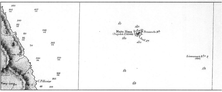
In 1857 the Russian Navy mapped Dokdo as part of their Map of Korea´s Coast. Argonaut Island was omitted and both Ulleungdo and Dokdo were mapped in correct locations. Here Dokdo is drawn in great detail and the 132 degree line of longitude can be seen.
The 1876 British map above shows Argonaut Island had since been removed from maps by this time.

A full map of Japan-Korea from Adolf Stieler in the year 1870

The map by J Migeon is dated 1874 shows correct positioning, and again, Argonaut Island has been deleted.
In Conclusion
From the Meiji Era there exist maps and documents that show the Japanese excluded Ulleungdo and Dokdo from Japanese territory. Some Japanese maintain that during this time era (1870-80) their government was so confused that these maps and documents arenÀ₤t applicable. We can see this is wrong by referencing a few sources. First, by reviewing the above maps we can see that although the Japanese followed Siebold´s error and repositioned both Ulleungdo and Dokdo, it´s clear that the island names they were originally meant to denote remained the same. That being said, it would be wrong to dismiss a map such as Mori Kineski´s map on the basis of Ulleungdo and Dokdo´s poor positioning. Secondly, Europeans discovered Liancourt Rocks in 1849, creating a brief period of confusion that was resolved by both the Russians and English no more than ten years later. British Royal Navy maps show that, by 1863, Argonaut´s existence was doubtful. Japan´s Naval maps and records tell us they followed closely the mapping trends of the Europeans, most notably the British, thus it is unlikely more informed members of the Japanese government thought differently. The 1870 Official Inquiry Regarding how Ulluengdo and Dokdo became Chosun possession makes clear that the Jukdo (þÆÆ—) Island being referred to is the Ulleungdo Island that was disputed during the Genroku period. Thus we know the Japanese were not referencing later maps because they refer to Ulleungdo as Songdo (ÃÌÆ—). The 1877 Document by the Dajokan also states this historical linkage to Ulleungdo (þÆÆ—) from the Genroku Era. The accurate locations of Ulleungdo and Dokdo given in this document prove that the Japanese were using maps and documents that pre-dated both Seibold´s error and the time period in which three islands were mapped. Japanese documents such as Watanabe Kuoki´s paper of 1878 show us the Japanese had known for some time that Jukdo (Argonaut) did not exist, Songdo was Ulleungdo and the former Songdo was Liancourt Rocks. If there was any confusion at this time it could be said the Japanese were concerned there might be another land mass in the region besides Ulleungdo and Dokdo. Lastly, we must consider the following: The policy of the Meiji government on Dokdo became clear when it was determined that no other islands existed in the vicinity. National maps of Japan and regional maps of Shimane Prefecture after the year 1880, more often than not, fail to show both Ulluengdo and Dokdo. This is clear evidence that historically, the Japanese did not consider Dokdo as part of Japan prior to its illegal annexation.